

Saving Our Wetlands
by John Shribbs, 2021

Marshlands are transition zones between the land and ocean and evolve over geologic time with tectonic plate movement, erosion, and sea-level changes. Sadly, SF Bay has already lost much of its marsh habitat in the last 150 years. Our shores were historically lined with 200,000 hectares, or approximately 770 square miles, of salt marshes, but urban development, landfilling, and the construction of dikes, levees, and dams caused an 80-90% loss of these areas over the 20th century. Although 5,000 hectares of these lost marshes have been restored, projected rates of sea-level rise threaten the Bay’s remaining 13,209 hectares of marshes. Agencies, lawmakers, and urban planners must take preventative steps to protect the Bay’s vulnerable tidal marshes from sea level rise.
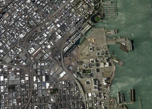
Wetlands have been filled and built upon. Dikes hold the water off the land.
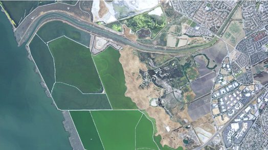
Dike systems were built to manage water levels to create ponds for salt harvesting.
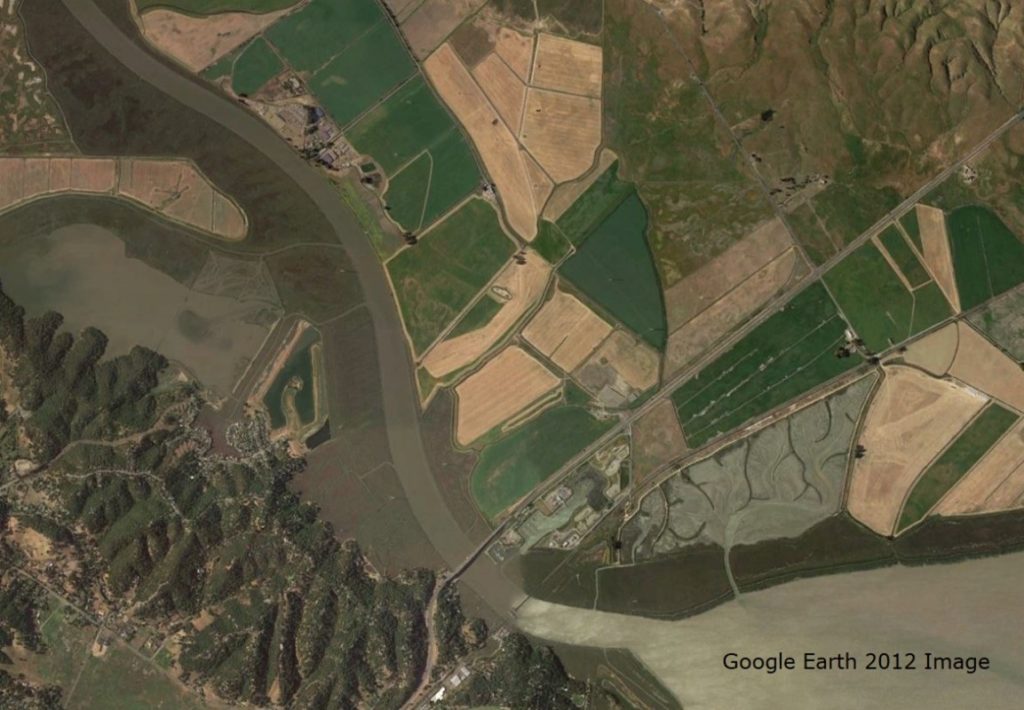
Google Earth image from 2012 shows a large area was diked off the Petaluma Marsh for agricultural production. Much of the farmland has subsided, lowered in elevation, due to sinkage, no input of sediment, and loss of organic matter to the atmosphere.

SF Bay Changes with Ice Ages and Climate Change
Twenty thousand years ago, the Pacific coastline was 27 miles west of the Golden Gate, with coastal hills whose tops are now the Farallon Islands. As the great ice sheets began to melt, around 11,000 years ago, the sea level started to rise. By 5000 BC the sea level rose 300 feet (90 m), filling the valley with water from the Pacific. The valley became a bay, and the small hills became islands. Image from KQED website.

This is the shape of SF Bay 1,000-3,000 years ago. The Sacramento and San Joaquin rivers carried huge flows of water and sediment down from the Sierra Nevada Mountains which accumulated along the shallow shores of the new bay, creating marshes and mudflats that supported plant and animal life. Most of the edges turned into marshes and estuaries with large transition zones between water and land.

Even with slight recent sea level rise, the bay is smaller now than 150 years ago, More than 90% of California’s original marshland has been degraded, destroyed or “reclaimed” by urbanization, agriculture, and commercial salt operations. In the San Francisco Bay, less than 15% of original tidal marshland remains-much of it highly fragmented or altered. Only 27% of the historic tidal marshes in San Pablo Bay remain.

Sedimentation will not keep up with rising water which means most of the current marshland remaining in the SF Bay will become mudflat, including our Petaluma Marsh. Since marshes cycle and store more carbon than mudflats, this will release more carbon dioxide to the atmosphere.
Climate Change is also going to increase the frequency and severity of both droughts and floods, enough so that we should be using the term Hydrologic Cycle Disruption as well as Climate Change. With sea-level rise also comes higher groundwater tables with saltwater intrusion into groundwater and more coastal flooding with the erosion of dikes and sea walls and overtopping of dikes.
With rising sea levels, models from research data predict most of our marsh will turn into mudflats since the sedimentation will not keep up with water rise and drowning all vegetation. Marshland will move uphill if there is enough space with near level ground. Our entire Petaluma Marsh could one day look like Grey’s Marsh imaged below that has been a mudflat for more than 20 years.
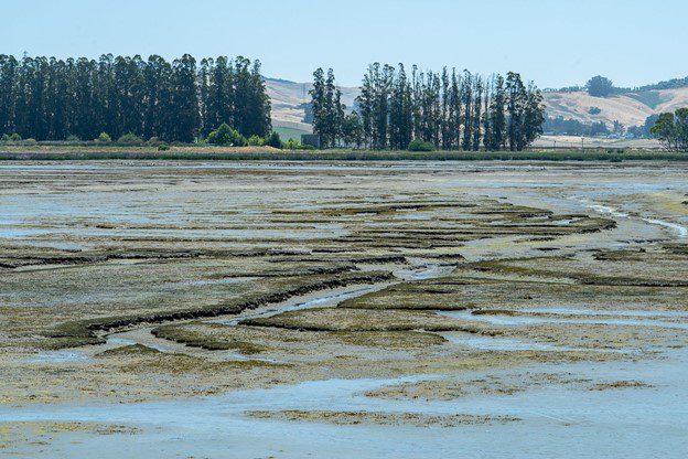
Photo from Tim Morgan. Gray’s Marsh mudflats.
Petaluma River and Marsh Modified in Last 150 Years
The Petaluma Marsh is the largest remaining salt marsh in San Pablo Bay, totaling an estimated 5,000 acres. The Petaluma River watershed includes a diversity of freshwater, brackish water, and saltwater habitats. The marsh has three zones: a low marsh of cordgrass or tules, which receives maximum submergence; a middle marsh of pickleweed, alkali bullrush, or cattails; and a high marsh, which is rarely, if ever, covered by tidal action. These tidelands provide food and shelter for millions of shorebirds and hundreds of thousands of waterfowl that migrate through or winter every year. During extreme high tides, the surrounding uplands are a refuge for many marsh animals.
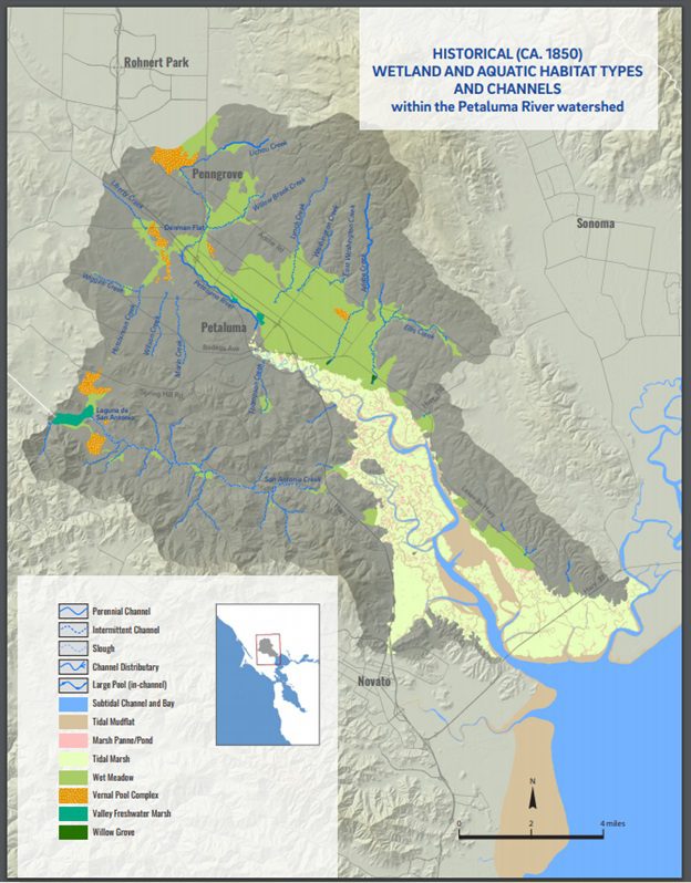
This historical wetland map shows much of the lower elevations of the watershed were marsh and meadow wetlands. Image from Baumgarten, S.; Clark, E.; Dusterhoff, S.; Grossinger, R. M.; Askevold, R. A. 2018. Petaluma Valley Historical Hydrology and Ecology Study. SFEI Contribution No. 861. San Francisco Estuary Institute: Richmond, CA.
Petaluma Marsh and Wetlands at Risk
Our Petaluma River and Marsh have changed by human efforts after European settlement. Beginning in the late 19th century, thousands of acres of tidal marsh were diked and drained in an effort to reclaim lands for agricultural use. The construction of transportation corridors and industrial infrastructure further contributed to tidal wetland loss. The Laguna de San Antonio wetland complex was ditched and drained in the late 19th century, though highly modified wetlands still occupy several hundred acres at the head of San Antonio Creek. Before suburban development in the 1970s, the east side of Petaluma was a wet meadow, and creeks spread out in deltas onto an alluvial plain. Besides the marshlands, the large wet meadow that occupied much of the valley floor east of the Petaluma River has been almost completely eliminated, as have the vast majority of vernal pool complexes throughout the watershed.
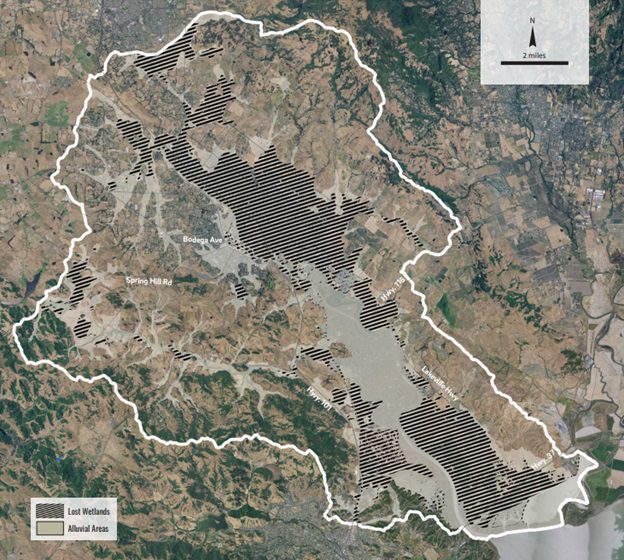
This map shows the tidal and nontidal wetlands in alluvial areas decreased by over 18,000 acres over the last two centuries. Of the original 5,000 acres marsh only about 2,000 acres are still considered tidal estuary marsh, but it is still the largest and best-preserved ancient salt marsh on the West Coast. Wetland loss has greatly reduced habitat for a number of plants and animals and has also impaired numerous ecosystem services such as floodwater storage and fine sediment retention. Image from: Baumgarten, S.; Clark, E.; Dusterhoff, S.; Grossinger, R. M.; Askevold, R. A. 2018. Petaluma Valley Historical Hydrology and Ecology Study. SFEI Contribution No. 861. San Francisco Estuary Institute: Richmond, CA.
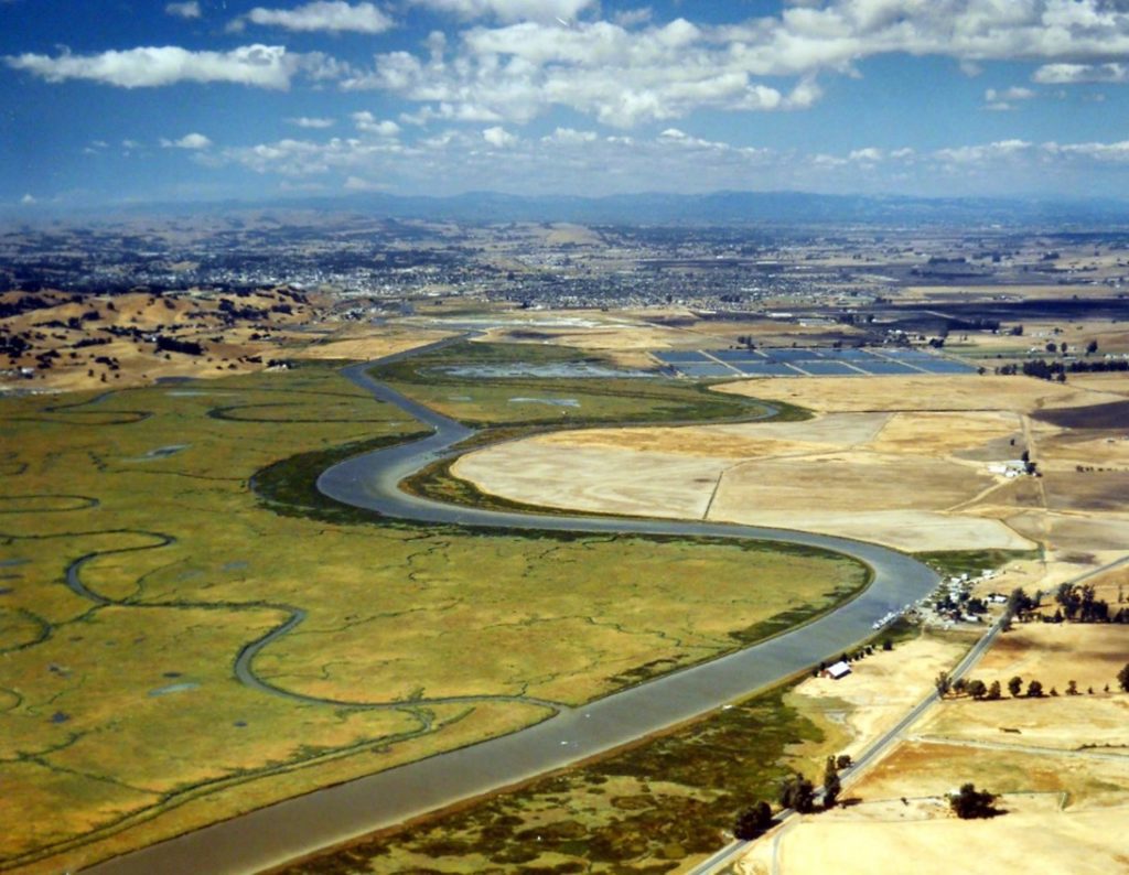
In the following image looking north toward Petaluma, you can see the ancient marsh on the west side (left side) of the slough while the east side (right side) was diked for farmland. Also, notice the dendritic pattern of weaving water channels and the straightening of the channel cutting out a sharp loop that was hard to navigate. Since the marsh is fairly flat, during heavy rains at high tide the entire marsh can be underwater.
Image of Petaluma River looking North from Small Craft Association
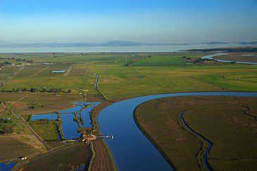
In the following image looking south toward SF Bay notice the marsh on the west (right) side has many tidal pools at high tide and the east (left) side. From: Scott Hess.
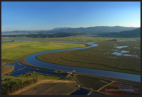
In this image looking south toward San Pablo Bay notice the many agriculture fields that are still under production. These lands, once part of the tidal marsh, are subsiding (lowering in elevation) since sediment is no longer being deposited there and organic matter is decomposing and gassing off as carbon dioxide. From: Scott Hess
Wetland Zones and Habitats
The following image of the transition zones in a marsh from aquatic to terrestrial shows the shifts in vegetation with elevation. (click on image to enlarge or zoom in)
Slight changes in elevation creates a dendritic pattern that looks like bare tree branches which result in different water, salt, and organic concentrations. These change with tides based on sun and moon positions twice every 25 hours. The slight changes in the physical environment create micro-niches for plants, so you see strong association of this dendritic surface pattern and vegetation patterns. Image from SFEI Historical Hydrology Study.


Notice the vegetation diversity with patterns in this image. As tides move in and out, birds and animals move between feeding ground and cover from predators.
The Petaluma Marsh is the largest remaining salt marsh in San Pablo Bay, totaling an estimated 5,000 acres. The marsh has three zones: a low marsh of cordgrass or tules, which receives maximum submergence; a middle marsh of pickleweed, alkali bullrush, or cattails; and a high marsh, which is rarely, if ever, covered by tidal action. During extreme high tides, the surrounding uplands are a refuge for many marsh animals.
Numerous special status invertebrates, fish, amphibians, reptiles, birds, mammals, and plant species are known to occur within the Petaluma River watershed. A number of species are federally listed under the Endangered Species Act (ESA). Among those are the California red-legged frog, California freshwater shrimp, steelhead trout, chinook salmon, Ridgway’s rail, and salt marsh harvest mouse. The habitat varieties identified in this region are vital for the survival of such species. For example, the California clapper rail, California black rail, and the salt marsh harvest mouse are completely dependent upon marshlands. The California clapper rail and the salt marsh harvest mouse survive only in tidal marshlands; whereas the California black rail lives in freshwater and saltwater marshland habitats.
In addition to special status species, the watershed supports an array of resident native and migratory bird species. Resident species include the San Pablo song sparrow and California black rail. A significant amount of the state’s Pacific flyway migratory waterbirds relies on the watershed’s wetlands. Exceptionally large numbers of migrant and wintering waterfowl occur here, particularly canvasback. Other waterfowl that occur in exceptional numbers include northern shoveler, ruddy duck, bufflehead, and greater scaup. The North San Francisco Bay tidelands provide food and shelter for millions of shorebirds and hundreds of thousands of waterfowl that migrate through or winter every year.
The Petaluma River is a diverse habitat supporting 25 species of marine, estuarine, and freshwater fish. Twelve of the twenty-five species are native to California. The Petaluma River hosts a number of fish species, which are currently listed as “threatened” by the National Marine and Fisheries Service. These species use the Petaluma River and its tributaries as a habitat for spawning, rearing, and migration.
Ecological balance, the equilibrium between, and harmonious coexistence of, organisms and their environment are critical to maintaining a healthy watershed. A stable balance in the numbers of each species in an ecosystem depends on how much it is affected by the human population and development. The balance may be disturbed by several factors such as the introduction of new species, the sudden death of species, natural hazards, or man-made causes. The many diverse species present in the Petaluma River watershed depend on symbiotic relationships to survive. As land is preserved and resources are managed effectively, fish and wildlife will have a chance to thrive in this watershed.
Ecosystem Services
It is no accident that river valleys and coastal plains with abundant wetlands have been the focus of human civilizations for over 6,000 years – and that these wetland systems, with their rich natural resources, have been critical to the development and survival of humanity. Wetlands were once considered useless, disease-ridden places (e.g., malaria and yellow fever) that were to be avoided. We now realize that wetlands provide many benefits to society – such as fish and wildlife habitats, natural water quality improvement, flood storage, shoreline erosion protection, opportunities for recreation and aesthetic appreciation, and natural products for our use at little or no cost.
Ecosystem services – the benefits people obtain from ecosystems – provided by wetlands include:
- Flood control
- Groundwater replenishment
- Shoreline stabilization & storm protection
- Sediment & nutrient retention and export
- Water purification
- Reservoirs of biodiversity
- Wetland products
- Cultural values
- Recreation & tourism
- Climate change mitigation and adaptation
The Convention on Wetlands of International Importance, more commonly known as the Ramsar Convention, is an international agreement promoting the conservation and wise use of wetlands. These ten services are discussed in detail in Ramsar fact sheets available in PDF in several languages by typing in the search words “ecosystem services” into the search bar and indicating “documents” and “factsheets.”
Wetlands with the Ramsar designation are selected based on their international significance in terms of ecology, botany, zoology, limnology, or hydrology. Worldwide, there are 2,388 Ramsar-designated wetlands. Representing Petaluma are:
- Alman Marsh tidal wetlands
- Shollenberger Park wetlands
- Gray’s Marsh tidal wetlands
- Ellis Creek Water Recycling Facility wetlands
- Hill Property tidal wetlands
The Ramsar designation came about thanks to a partnership between the City of Petaluma and the Petaluma Wetlands Alliance.
Another good read on ecosystem services provided by wetlands is the EPA Wetland Functions and Values.
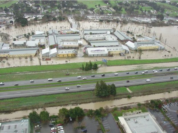
Petaluma has flooded many times in the past and many flood reduction systems were put in place, but flooding is still occurring. This image was taken during a recent flood event in 2005 when Outlet Mall was under several feet of water due to a combination of saturated soils, heavy rainfall, and a king tide. The entire Petaluma Marsh was underwater. For more information on flooding in Petaluma see the Flooding web page on this site.
Protecting wetlands can, in turn, protect our health and safety by reducing flood damage and preserving water quality. Wetlands are among the most productive ecosystems in the world, comparable to rain forests and coral reefs. They also are a source of substantial biodiversity in supporting numerous species from all of the major groups of organisms – from microbes to mammals. Physical and chemical features such as climate, topography (landscape shape), geology, nutrients, and hydrology (the quantity and movement of water) help to determine the plants and animals that inhabit various wetlands. Wetlands in Texas, North Carolina, and Alaska, for example, differ substantially from one another because of their varying physical and biotic nature.
Carbon Storage
Soil carbon is vital in regulating climate, water supplies, and biodiversity—all essential contributions to the provision of ecosystem services. Wetlands contain a disproportionate amount of the earth’s total soil carbon; holding between 20 and 30% of the estimated 1,500 Pg (Picograms) of global soil carbon despite occupying 5–8% of its land surface. The anoxic conditions characteristic of wetland soils slow decomposition and lead to the accumulation of organic matter. As a result, wetlands can accumulate large carbon stores, making them an important sink for atmospheric carbon dioxide and holding up to or, in some cases, even more than 40% soil carbon, which is substantially greater than the 0.5–2% carbon commonly found in agricultural soils. Freshwater inland wetlands, in part due to their substantial areal extent, hold nearly ten-fold more carbon than tidal saltwater sites—indicating their importance in regional carbon storage. In the United States, more than half of the historical wetland area has been lost due to anthropogenic activities resulting in a net transfer of carbon from the soil to the atmosphere. This is particularly true for freshwater inland wetlands that make up most of the wetland area comprising, for example, 95% of all wetlands in the conterminous United States. Many studies have focused on quantifying the carbon held in terrestrial ecosystems (green carbon) and, more recently, on the carbon held in tidal saline ecosystems (blue carbon); however, our knowledge of carbon stored in inland freshwater wetlands (teal carbon) is often overlooked or limited to site-specific studies. Accurate carbon accounting in wetlands is vital to reduce the risk of climate change contributions by identifying and protecting wetlands or wetland-dominated landscapes that hold disproportionately large carbon stocks and to allow the inclusion of wetlands in carbon offset programs. We need to protect wetlands to mitigate the risk of avoidable carbon dioxide release to the atmosphere and not contribute to climate change.
Since much of Petaluma has been built on top of a large area of wetlands, we lost the originally stored carbon in the soil and need to replenish the soil carbon by planting more native trees and bunch grasses
Wetland Restoration using Nature Based Solutions
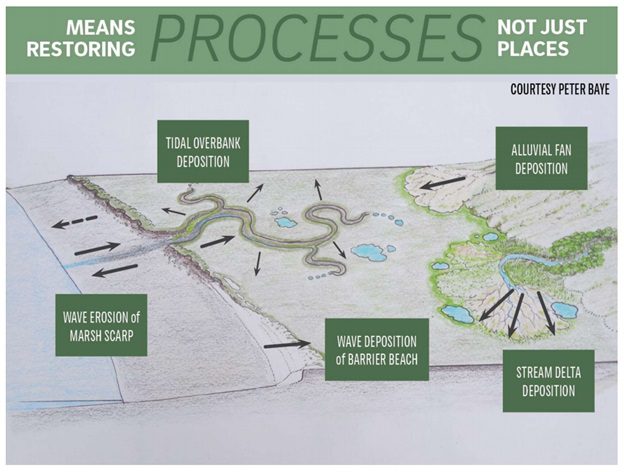
The following image from SFEI suggests using nature-based solutions to several water management systems. We want to restore natural processes that allow gravity and slow changes to develop a more resilient system that will be more efficient and cost-effective in the long run.
To compare the traditional method of water management to more nature-based systems the following diagram (from Dusterhoff) shows the historical system that was modified by channelizing water flow or cutting it off and moving it to larger channels, essentially removing all deltas, alluvial fans, and areas where water could spread out. Nature-based solutions include allowing water to spread into the marsh (left), adding water catchment basins (center) that can help with groundwater recharge, and reforming alluvial fan areas (right) to slow water down and spread sediment.
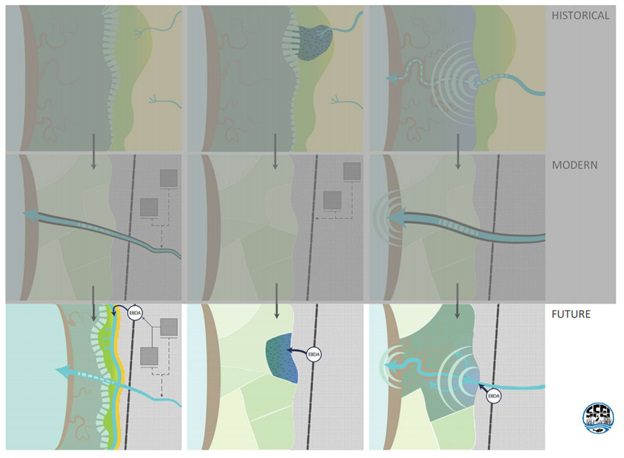
This remediation can be done near the wetlands, but some can also be done where we channelized our creeks.
Sedimentation will not keep up with rising water which means most of the current marshland remaining in the SF Bay will become mudflat, including our Petaluma Marsh. Farmlands behind dikes are subsiding or sinking so groundwater with high salt content is emerging behind the dikes. Higher water levels and stronger wave action causing dikes to be overtopped with water or eroded resulting in severe flooding of the farmlands. Up to now, the solution has been to build bigger and higher dikes and pump water out of the farmland. Some of this pumping is currently saving Hwy 37 from being flooded. Many government agencies are working on finding a solution to increase the recurrence of flooding of Hwy 37, the main artery of car and truck transit.
Much of the ecosystem services will be diminished, especially the amount of habitat remaining for plants and animals reducing biodiversity. Since marshes cycle and store more carbon than mudflats, this will release more carbon dioxide into the atmosphere.
We need to start now and work hard over the next 10 years to save the SF Bay shorelines and to save Petaluma Marsh. These are the methods currently recommended for the entire SF Bay region to prepare our wetlands for rising sea levels:
- Restore estuary-watershed connections.
- Design complexity and connectivity into the Baylands landscape.
- Restore and conserve complete tidal wetlands systems.
- Restore Baylands to full tidal action prior to 2030.
- Plan for the Baylands to migrate.
- Actively recover, conserve, and monitor wildlife populations.
- Develop and implement a comprehensive regional sediment management plan.
- Invest in planning, policy, research and monitoring.
- Develop a regional transition zone assessment program.
- Improve carbon management to prevent further subsidence, increase organic matter accumulation, reduce GHG emissions, and sequester more carbon.
SF Bay has been categorized into designated units with several slated for restoration with the goal of 100,000 acres of restoration. Prior restoration efforts were mainly done by grading the land behind the dikes to allow more natural water flow patterns, breaking a dike barrier to allow water to flow tidally, and adding native plants to restore habitats. Sometimes just breaking the dikes and allowing nature to take its own course has given good results with water movement naturally making the changes which also bring in plant propagules to reseed the habitats. Natural systems can recover if given time and opportunity.
The following are two examples of large projects already completed or advanced in progress.
The South Bay Salt Pond Restoration Project is the largest tidal wetland restoration project on the West Coast. When complete, the Project will restore 15,100 acres of industrial salt ponds to a rich mosaic of tidal wetlands and other habitats. Southbayrestoration.org
The SF Bay Restoration Authority is tracking 21 current projects in the SF Bay.
Projects in or near Petaluma Marsh
One step is to purchase privately-owned parts of the Petaluma Marsh and then start the restoration work. Examples of this are the Sears Point Restoration by Sonoma Land Trust and the Mira Monte land purchase by Marin Audubon.
Part of the San Pablo Baylands Project was done at Sears Point near the mouth of Petaluma River.
Marin Audubon was able to acquire over 100 acres north of Redwood Landfill and broke down the dikes to restore marshland. In 2003, Audubon purchased the land from Waste Management Inc. – which operates the landfill – for $275,000, half of its assessed value. The state Coastal Conservancy then gave Audubon $1.6 million for wetlands restoration.
Future projects using Nature-Based Solutions
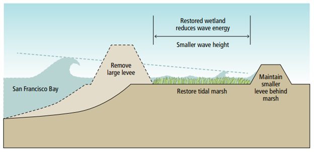
Another proposal is to work with private landowners currently doing an agricultural service in the lower Petaluma River to shift how they manage their dikes. Instead of building bigger, higher front dikes, experts are recommending moving the dike back and grading the land in front with a gradual slope that breaks of wave action and provides space for marsh habitat that slows water energy from reaching the main dike. This is the proposal by Sonoma Land Trust presented in a recorded webinar, Petaluma Baylands Strategy Community Meeting (4/27/21).
The following diagram shows a simplified version of redesigning dike systems to reduce wave energy. In this version, the new “retreated” levee can even be smaller and shorter than the original front levee.
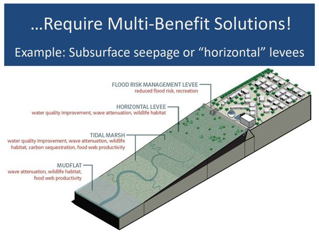
Another system proposed is the “horizontal levee” where sediments are loaded onto the land to create a gradual long slope.
Other methods proposed include placing piles of dredge spoils where natural water flow will move the sediment and lay them down naturally. Most of these concepts of meeting the challenge of rising sea level is to use sediments from dredging waterways with additional sediment from the bay and placing them where needed. There are several other methods that can be used around the bay including modifying beaches and storm walls, but sediment layering seems to be the most cost-efficient and effective. The volume of sediment needed is quite large and will take long-range planning and funding.
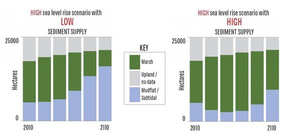
The following graphs (based on Toms webinar presentation) compare no action (low sediment) to adding large amounts of sediment (high sediment) during sea-level rise can shift the substrate structure increasing the marshland and minimizing the mudflats.
Innovative approaches to making managed ponds and marshes more resilient could be pursued for retrofitting existing diked baylands or constructing new ones. These might include designs for more flexible water-control structures or water management configurations that can accommodate changes in sea level. Also, there may be ways to allow the bathymetry of managed ponds and marshes to rise with sea levels by capturing sediment, which could ameliorate the need for reinforcing levees and pumping water. Habitat types will naturally shift over time due to sea-level rise, salinity changes, and restoration. To ensure that the habitat needs of waterbirds are being met, a large-scale, long-term planning and monitoring effort across the bay, delta, and Central Valley (and ideally the rest of coastal California) is needed. The reliance of Pacific Flyway waterbirds on baylands habitats is partly due to the extensive loss of wetlands in the Central Valley (particularly the delta) and other parts of coastal California.
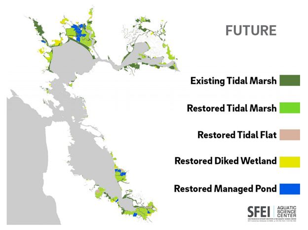
Following is a map (from SFEI) of potential areas of wetland restoration in the Petaluma Watershed. Click on the image to enlarge or zoom in.

Sources of Images and Maps and Resources for More Information:
Baumgarten SA, Clark EE, Dusterhoff SR, Grossinger RM, Askevold RA. 2018. Petaluma Valley Historical Hydrology and Ecology Study. Prepared for the Sonoma Resource Conservation District and U.S. Environmental Protection Agency. A Report of SFEI-ASC’s Resilient Landscapes Program, SFEI Publication #861, San Francisco Estuary Institute, Richmond, CA. Available online at: https://www.sfei.org/documents/petaluma-valley-historical-hydrology-and-ecology-study.
Baig, Yousef. “No Petaluma River dredging next year”. ARGUS-COURIER. December 10, 2018. Available online: https://www.petaluma360.com/article/news/no-petaluma-river-dredging-next-year/
City of Petaluma. “Petaluma Watershed”. https://cityofpetaluma.org/petaluma-river-watershed/
Dusterhoff, S.; McKnight, K.; Grenier, L.; Kauffman, N. 2021. Sediment for Survival: A Strategy for the Resilience of Bay Wetlands in the Lower San Francisco Estuary SFEI Contribution No. 1015. San Francisco Estuary Institute: Richmond, CA. Available online: https://www.sfei.org/biblio/author/212%3Fsort%3Dyear%26order%3Dasc?f%5Bauthor%5D=1078
Grossinger, Robin. May 20, 2021. Sea-Level Rise: Why We Need Nature-based Adaptation Webinar Series. San Francisco Estuary Institute www.sfei.org Ecology of the Bay Past and Future. Full webinar available online: https://www.youtube.com/watch?v=l8D8-ZGUhUE
And Powerpoint available online: https://www.sierraclub.org/sites/www.sierraclub.org/files/sce-authors/u31361/Robin%20Grossinger%20PowerPoint.pdf
California State Coastal Conservancy, Oakland, CA. Goals Project. 2015. The Baylands and Climate Change: What We Can Do. Baylands Ecosystem Habitat Goals Science Update 2015 prepared by the San Francisco Bay Area Wetlands Ecosystem Goals Project. Available online: https://www.sfei.org/sites/default/files/biblio_files/Baylands_Complete_Report.pdf
Grenier, Letitia. 2021. Climate change, Bay wetlands, and actions we can take. Sierra Club Webinar Series, May 20, 2021. Available online: https://www.youtube.com/watch?v=l8D8-ZGUhUE.
California State Coastal Conservancy: Oakland, CA. “The Baylands and Climate Change: What We Can Do. Baylands Ecosystem Habitat Goals Science Update 2015”. Available online at: https://www.sfei.org/documents/baylandsgoalsreport.
Climate Central. “Sea level rise threatens plant life in estuaries and salt marshes”, 2018. Available online at: https://www.climatecentral.org/library/climopedia/sea_level_rise_threatens_plant_life_in_estuaries_and_salt_marshes
Dusterhoff, S.; McKnight, K.; Grenier, L.; Kauffman, N. 2021. Sediment for Survival: A Strategy for the Resilience of Bay Wetlands in the Lower San Francisco Estuary. SFEI Contribution No. 1015. San Francisco Estuary Institute: Richmond, CA. Available online: https://www.sfei.org/documents/sediment-for-survival
Intergovernmental Panel on Climate Change. “Global Warming of 1.5°C. 2018”. Available online at: https://www.ipcc.ch/sr15/
Karen M. Thorne, John Y. Takekawa, and Deborah L. Elliott-Fisk (2012) “Ecological Effects of Climate Change on Salt Marsh Wildlife: A Case Study from a Highly Urbanized Estuary”. Journal of Coastal Research: Volume 28, Issue 6: pp. 1477 – 1487. Available online: https://www.jcronline.org/doi/abs/10.2112/JCOASTRES-D-11-00136.1?journalCode=coas.
Laffoley, D. & Baxter, J. M. (editors). 2016. “Explaining ocean warming: Causes, scale, effects and consequences”. Full report. Gland, Switzerland: IUCN. 456 pp. Available online at: https://portals.iucn.org/library/sites/library/files/documents/2016-046_0.pdf
Mitsch, William J. and James G. Gosselink. “Wetlands”, 4th Edition. 2007.
Oikawa, Patty. 2021. Carbon Sequestration and Greenhouse Gas Budgets in Restored Tidal Wetlands. Sierra Club Webinar, May 13, 2021. Available online: https://www.youtube.com/watch?v=mWqw36O3qtE.
Nahlik, A., Fennessy, M. 2016. Carbon storage in US wetlands. Nature Communications 7, 13835. Available online: https://doi.org/10.1038/ncomms13835.
“Petaluma River, Detailed Project Report for Flood Control, Sonoma County: Environmental Impact Statement”. 1994. Available online: https://books.google.com/books?id=Ej80AQAAMAAJ&source=gbs_navlinks_s
Ridolfi, Kat and Lester McKee and Sarah Pearce. Aquatic Science Center. “Petaluma River Impairment Assessment for Nutrients, Sediment/Siltation, and Pathogens”. 2010. Available online: https://www.sfei.org/sites/default/files/biblio_files/Petaluma_IA_submitted_to_RWQCB_April_2010.pdf
Romans, Brian. Sep 2, 2010. The Importance of Studying the History of Sea-Level Change in San Francisco Bay. KQED. Available online: https://www.kqed.org/quest/7788/.
Sonoma County Water Agency. SOUTHERN SONOMA COUNTY STORM WATER RESOURCES PLAN. 2019. https://www.sonomawater.org/media/PDF/Water%20Resources/Stormwater/Stormwater%20Resource%20Plan/Southern_Sonoma%20County_SWRP_Final%20Update_2019-05.pdf
Sonoma RCD. Draft Petaluma Watershed Enhancement Plan. 2015. https://sonomarcd.org/wp-content/uploads/2017/06/Petaluma-Watershed-Enhancement-Plan-2015.pdf
Southern Sonoma County Resource Conservation District. “Petaluma Watershed Enhancement Plan”. July 1999.Available online: https://www.waterboards.ca.gov/water_issues/programs/tmdl/records/region_2/2003/ref1330.pdf
Toms, Christina. May 13, 2021. How Tidal Wetlands and Nature-Based Infrastructure Support a Clean, Healthy Bay. What is Nature-Based Adaptation? Webinar by Sierra Club. Available online: https://www.youtube.com/watch?v=mWqw36O3qtE.
Tracy Nishikawa, D. S. Sweetkind, N. F. Teague, and Jonathan Traum. Geohydrologic Characterization, water-chemistry, and hydrologic Model of the Petaluma Valley Watershed, Sonoma County, CA. USGS. 2019. Available online at: http://petalumavalleygroundwater.org/wp-content/uploads/10-26-17-USGS-Presentation-1.pdf
U.S. Fish and Wildlife Service. 2013. Recovery Plan for Tidal Marsh Ecosystems of Northern and Central California. Sacramento, California. xviii + 605 pp. Available online: https://www.fws.gov/sfbaydelta/documents/tidal_marsh_recovery_plan_v1.pdf.