

Dredging
by John Shribbs, 2021
Updated: January, 2026
Without dredging the river would slowly fill with silt and no longer be navigable for commercial or large recreational vessels and causing a decline in river-related tourism. Since Petaluma ships provided much of the eggs, dairy, and hay during the Gold Rush Era, our town had the richest population in the US for a few years. Dredging was essential to this intensive shipping industry.
Early History of Dredging
Since the 1880s the Army Corp of Engineers (ACOE) improved and maintained the Petaluma Creek for navigation. The Corps’ dredging project from 1930 to 1933 provided for a 200-foot wide, 8-foot-deep channel for 33,000 feet across the mudflats in San Pablo Bay to the mouth of the Petaluma Creek. For the next 69,000 feet upstream to Western Avenue in the City of Petaluma, the channel was widened 100 feet and deepened 8 feet. Included in this part of the project was 300 feet x 400 feet turning basin, 8 feet deep. From Western Avenue upstream to Washington Street Bridge, the channel is now 50 feet wide and 4 feet deep. The San Francisco District of the ACOE maintained the San Pablo Bay Channel on a 144-month cycle and the Upper River channel on a 48-month cycle. Based on the Corps’ experience over the past 50 years, an average of 60,000 cubic yards of material is deposited in the river each year.
When the town was shipping hay and eggs to San Francisco during the 1850’s Gold Rush Era, the ship captains bragged about their ability to make the 80 turns in low visibility by timing each turn. Some were very sharp U-bends, and many ships grounded in the mud.
Navigation was eased by the elimination of thirteen U-shaped river bends from 1859 to about 1840, which shortened the river by about six miles from Hunt and Behrens to the mouth of San Pablo Bay.
 Map image of river cuts south of downtown Petaluma, courtesy of Petaluma Museum.
 Map image of river cuts in downtown Petaluma, courtesy of Petaluma Museum.
The steam dredgers deposited the spoils on a barge which was positioned along the shore where men with wheelbarrows moved the spoil over planks to the shore.
Chinese labor was hired for the removal of the first two U-shaped bends in 1859. Chinese labor was not hired to remove the third U-shaped bend in 1880 because of increasing anti-Chinese sentiment.
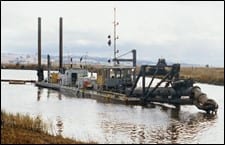
AB Bower’s suction dredger , introduced in the 1870’s pumped the dredge spoil in a slurry through a trailing flexible floating pipe. The end of the pipe was positioned at the dredge spoil site thus eliminating most of the manual labor.
 Image of Bowers Dredge System Courtesy of Sonoma County Library.
Besides straightening of the upper river many dikes were erected to channel the water and create cropland in prior marshland, especially in the lower river. The diagram below from the SFEI historic hydrology study is an early topological map that shows the sinuosity of the upper river.
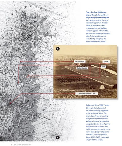
The river was straightened and channelized.
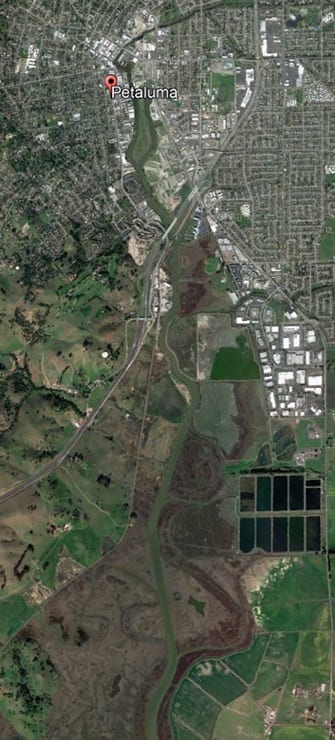
This next Google Earth satellite image of the upper Petaluma River shows where straight cuts were made. The prior curves become part of the marsh but are still visible due to different soil and vegetation. You can see dark brown areas where the river used to run over that are now part of the marshland or mudflat areas.
The following diagram from SFEI historic hydrology study shows how the river was changed over time. Water now moves faster in a narrower channel carrying more sediments further. Kayakers need to be careful when the water is moving fastest at mid tide times in the lower reaches.

How dredging works
 Dredging is typically done in autumn to protect migratory fish species. A dredger boat has some unique features. A “blender” 3 to 4 feet in diameter and many feet long chops up sediments as it slowly sweeps back and forth. A stream of surface water is constantly added to dilute the mixture of water and spoils. The resulting slurry is then pumped through a flexible pipe system up to three miles long and 24 inches in diameter. For years, this process delivered sludge to the Shollenberger central pond, officially an industrial waste site. Dredge spoils can be used as landfills and engineered soils for roads and dikes.
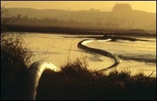 At this point, the sludge is about 10 – 15 percent sediment, and the rest is river water. In 2003, birds gathered around the dredge outfall because it was very rich in fish and invertebrates which they eat immediately and for many months following. Mammals such as river otters, muskrats, raccoons, and skunks may also join in the feast. The scraps from this feast quickly degrade to detritus, which enriches the water to stimulate plant and invertebrate growth. If the pond becomes too full, some of the water will be skimmed (decanted) from the surface after the sediment has settled. This decanted water is released through water gates into Adobe Creek, which returns it to the river.
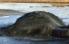
3 images pictures by Gerald Moore from 2003 dredging
Dredging is periodically needed and uses expensive equipment and requires several skills so most dredging operations are carried out by professional contractors. The videos below by dredging companies illustrate the mechanics of how dredging works.
Recent History of Dredging
Due to funding problems, the work scheduled for 2000 was not begun until 2002 and completed in 2003. Dredging was put on hold for 17 years. Justification to pay for dredging comes from the commercial tonnage of three river-using companies in Petaluma: Dutra Materials, Jerico Products, and Shamrock Materials. Although less of a lifeline than it was a century ago, the river still brings in an estimated $10 million annually to the local economy through commercial and recreational uses. The continued reduction of river traffic over time has resulted in the Army Corps downgrading the economic value of dredging the Petaluma River compared to other waterways. The cost of dredging has increased from approximately $1 per cubic yard to between $25 and $30 per cubic yard.
After the 2003 dredging, the USACE decided costs outweighed benefits and stopped dredging. After a 17-year hiatus, the river was dredged in 2020 and over 200,000 cubic yds of sediment were removed with a budget of over $10 million.
Autumn 2020 Dredging
The 2020 dredging was done by a company out of San Diego using electrical equipment.
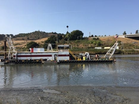
Image of dredger used in 2021. Photo by Len Nelson.
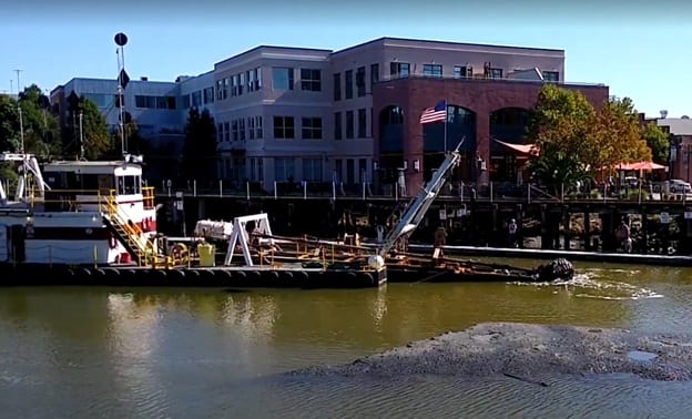
Image of the dredger with an extended drill in the Turning Basin. Photo by John Shribbs.
The operation is explained in this video by the city engineer overseeing the project.
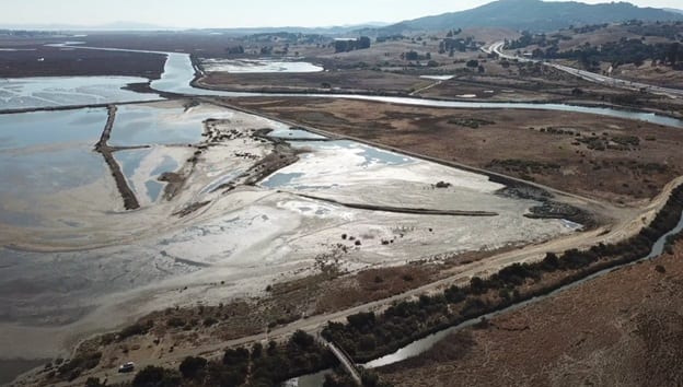
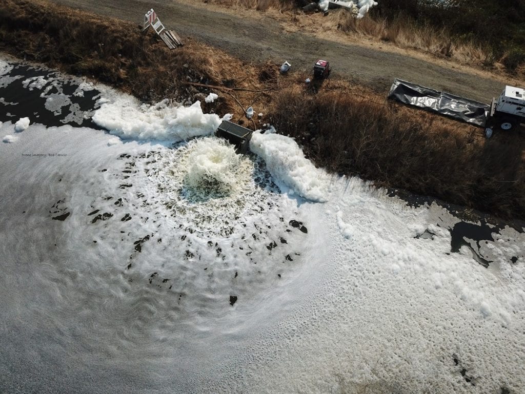
Image following shows the Shollenberger Central Pond filled with dredge spoils in 2021. Most of the sediment and trash dropped out of the pipe on the west side near the river. Dikes were set up to slow the water and spoils so sediments drop out and water can move to the other side where it is released back to the river. Drone image from Bob Caruso.
The image below is water being aerated before being released back into the river flow. Drone image from Bob Caruso.
Trash of all sorts come out with the recent dredge spoils including small plastic bits, bottles, plastic bags, crate parts, tires, toys, balls, dock floatation, boat parts, and even car parts. Future dredging will need to collect this human-made debris before deposition. PWA lead the community effort to pick up the debris from the Central Pond surrounded by the Shollenberger Park walkway. Over 14 sessions of 2 hours each were organized and an average of 10 volunteers joined the effort each day. On each day, a pickup truckload was removed.
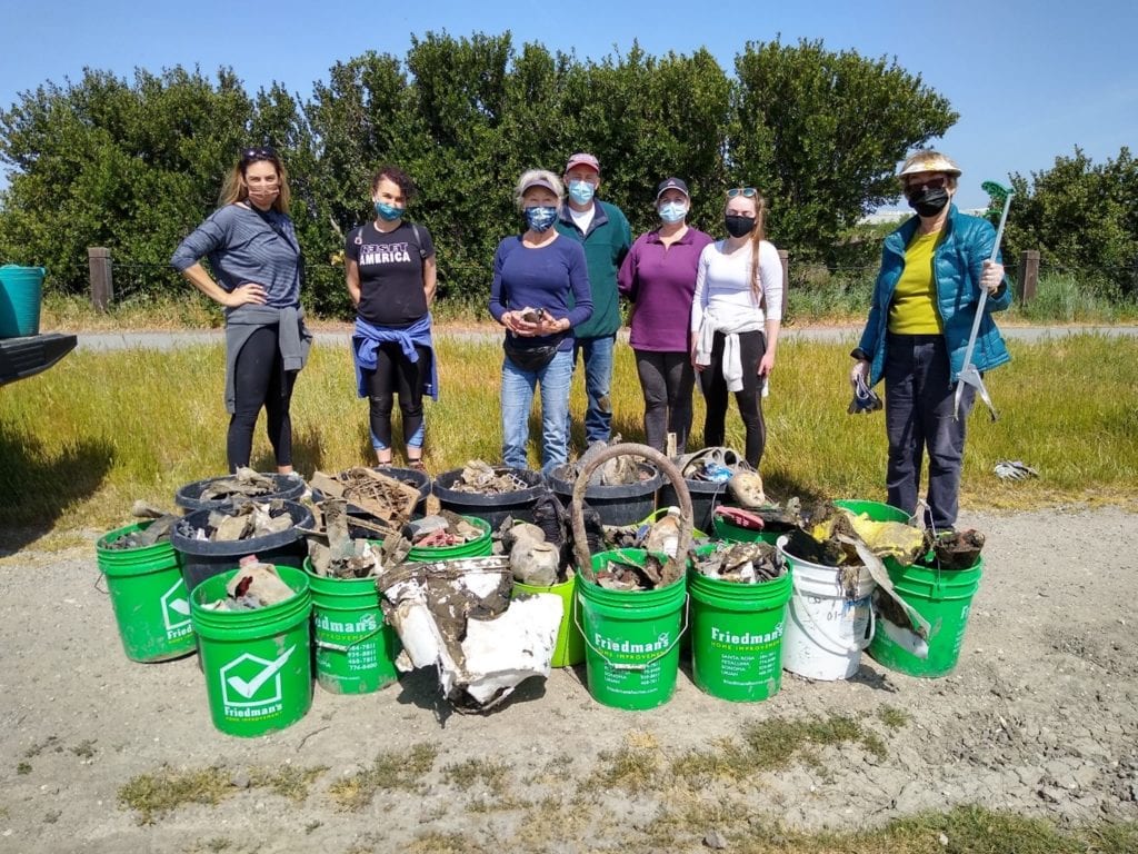
Image of volunteers with trash haul out of Central Pond. Photo by John Shribbs.
This video is an interview with Petaluma Mayor Teressa Barrett.
Future Dredging
Problems associated with siltation and flooding, recognized over a century ago, still exist today. Silt continues to accumulate.
The Army Corp performed the 2020 dredging under the condition that the city takes over all dredging operations in the future. Digging deeper and wider channels and straightening the curves to improve riverboat traffic changes the natural system. Nature responds by filling in any sediment we remove from the bottom of the channel to bring it back to its historical natural equilibrium. Continuous dredging, year after year, is costly, so we need to balance the economic value and review its sustainability. The city needs to weigh the costs of continuous, periodic dredging against the economic benefits to get a return on investment.
It is the city’s responsibility to find a dredge spoils site for the estimated 250,000 cubic yards of muck to be removed from the riverbed. The city plans to use these dredge spoils for habitat restoration. In the longer term, the city is working to establish an innovative regional partnership with the Sonoma County Water Agency, Marin County, the City of San Rafael, the Napa Flood Control District, and the Army Corps to dredge a series of overlooked channels across the North Bay.
References and Sources of Material
Baumgarten SA, Clark EE, Dusterhoff SR, Grossinger RM, Askevold RA. 2018. Petaluma Valley Historical Hydrology and Ecology Study. Prepared for the Sonoma Resource Conservation District and U.S. Environmental Protection Agency. A Report of SFEI-ASC’s Resilient Landscapes Program, SFEI Publication #861, San Francisco Estuary Institute, Richmond, CA. Available online here.