

Marsh Processes
by John Shribbs, 2021
Formation and Structure
Marshlands occur where the ocean meets land in flat areas and transitions from water (aquatic) habitat to land (terrestrial) habitat. Small changes in elevation and water movement with tides create zones of transition between the land and ocean. Marshes evolve over time with earth plate (tectonic) movement, erosion, and sea-level changes. A tidally influenced marshland like the Petaluma Marsh has a dendritic pattern of ditches that look like branches of an oak tree with vegetation shifting dramatically within inches of elevation change and described by habitat zones.

This diagram of a tidal marsh transition zones shows how vegetation shifts with tidal flow and elevation. Available online here
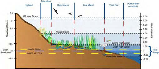
Size of tidal shifts, flow rates, and salt content all have a tremendous influence on survivability in these transition zones, so vegetation appears in narrow bands along the waterway which creates habitat niches for a variety of animal species.
Vegetation
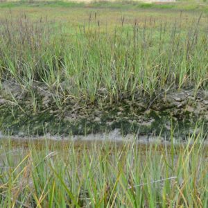
Vegetation traps particles that drop out of the water, called sediments, mostly small soil particles and organic matter, and that builds soil around the plants. Cordgrasses (Spartina spp.) and Bulrush/Tule (Schoenoplectus spp.) are major species that do this at the water edges. In the higher marsh, two dominant plant species, Pickleweed (Salicornia virginica) and Saltgrass (Distichlis spicata), are stress-tolerant species that can maintain their productivity under adverse conditions irrespective of local sedimentation deposition. The value of vegetation adapted to variable and elevated soil salinity is to substantially contribute to soil and organic matter building up in marshes.
Image of California Cordgrass, Sporobolus foliosus, at the edge of a water channel in a tidal estuary in the band at high tide mark. Source: USFWS Pacific Southwest Region. Available online here
Salinity
Water in an estuary, where water from rivers mixes with ocean water, contains variable amounts of dissolved salt. The salinity gradient generally increases from the input source of an estuary, usually a stream or river, to the output source, the sea or ocean. Salinity is measured as parts per thousand (ppt) of solids in liquid (1% = 10 ppt). The salinity of the ocean is generally around 35 ppt (3.5%). The freshwater from rivers has salinity levels of 0.5 ppt or less. Within the estuary, salinity levels are referred to as oligohaline (0.5-5 ppt), mesohaline (5-18 ppt), or polyaniline (18 to 30 ppt). Near the connection with the open sea, estuary waters may be euryhaline, where salinity levels are the same as the ocean at more than 30 ppt (3%).
An example of this is shown in the illustration below: Source: United States Environmental Protection Agency.
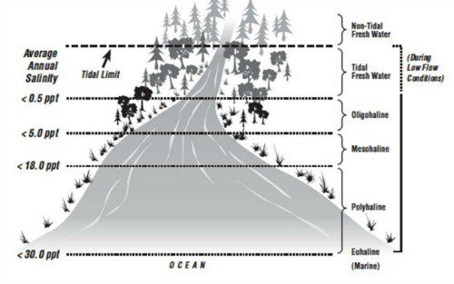
Our Petaluma River is a tidal slough with water salinity ranging from 0.5 to 2% making our Petaluma Marsh an oligohaline estuary. The salinity of an estuary can vary variable and dependent on the amount of fresh water flowing in, tides, elevation, physical location, and evaporation. Estuaries have a water balance that is either positive (freshwater inputs exceed evaporation), neutral (there is a balance between freshwater inflows and evaporation), or negative (freshwater inflows are less than the amount of evaporation). Seasonally, our Petaluma Marsh decreases in salinity in the winter months with increased rainfall and cooler temperatures and increases in salinity in the summer with decreased freshwater inflows and increased evaporation.
Salinity affects soil and water chemistry in estuaries, most notably the amount of dissolved oxygen. Solubility is the amount of oxygen that can dissolve in water, which decreases as salinity increases. Solubility is important because animals and smaller organisms have salinity ranges that they can tolerate before they experience stress. Some estuarine species such as fish can adapt to changes in oxygen levels by practicing avoidance techniques. Other organisms such as mollusks, oysters, and mud-dwelling organisms cannot travel large distances. Outside of their tolerance ranges, salinity levels cause negative effects, including increased stress and decreased reproduction and survival rates.
Organic matter
Organic matter such as bits of plants and animals, animal waste, decomposed bodies, tiny animals, and microbes are dissolved and suspended in water and attach to soil and sediments, and thereby carried into the marsh. Decaying plants and animals in the marsh also contribute larger organic particulate. Detritus is all the non-living organic matter and the associated microbial community. Carbon is the chemical element that forms the structural chains of all chemical compounds used by living beings. The marsh food web which uses detritus as the starting food source turns over more carbon than rainforests making saltwater marshes highly biologically active and productive ecosystems. The complex relationships between the living (biotic) and abiotic (nonliving) systems including water and sediment flows, vegetation, and the detritus food web have evolved over millennia, so the salt marsh ecosystem is robust, adapting to changes, and capable of surviving eventful impacts.
The Food Web
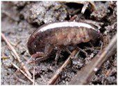 The food web on the marsh, like the marsh itself, is part aquatic and part terrestrial. The important primary producers are rooted, vascular plants such as grasses, small broadleaf plants, sedges, and rushes and sedges.Many of the primary consumers on the marsh are invertebrate herbivores, for example, snails, crabs, and grasshoppers, which eat plants while others are detritivores, such as salt marsh fleas, the most abundant taxa on the marsh, depending on the litter produced by the marsh plants. Many of these herbivores and detritivores become prey for fish at high tide, when flooding water provides access to the marsh surface. At low tide, they are fed upon by birds and small mammals.
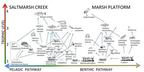
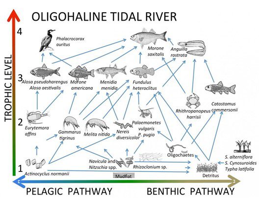
Following are images of marsh food webs with detritus as an essential component feeding small invertebrates at the lowest trophic levels. The trophic level starts at the simplest food source at the bottom and then each level above consumes the level below until the largest animals are at the top of the food chain and highest trophic level. Each trophic level retains about 10% of the energy in biomass and uses 90% for daily living. The Pelagic Pathway leads to water-based life forms and Benthic Pathway leads to bottom dwellers and soil substrate. These food chains are based on the detritus which is organic materials broken down and decomposed after the death of living organisms or plant parts. From University of Chicago Marine Biological Laboratory. Available online: https://pie-lter.ecosystems.mbl.edu/content/trophic-structure.
Feedback mechanism is a loop system in which the system responds to perturbation either in the same direction (positive feedback) or in the opposite direction (negative feedback). These food web relationships involve feedback systems that influence sediment deposition, soil formation, and marshland elevation so that even with the large volume of movement, the overall changes over a long time are slow.
Sediments
Sediments are small particles from natural sources of eroded rocks, soil, and organic (living and dead) sources but also human sources like road debris, trash, plastics, industrial waste, and wastewater that are carried by moving water and can settle out or be trapped and become part of the marsh system. Processes governing the movement of water and sediments in a marsh are very complex. Sediments are added and removed by tides, rain, erosion, trapping by vegetation, and amount of living matter (biomass).
Sediments flow up the Petaluma River and wetlands from ocean tides through the SF and San Pablo Bays. In addition, the Sacramento and San Joaquin Rivers transport large volumes of sediment through the Sacramento-San Joaquin Delta to San Pablo Bay, particularly in the rainy season, which can then enter the mouth of the Petaluma River and flow up with the tides. Tidal inflow and outflow, twice every 25 hours, constantly moves sediments up and down the river, making the river water “muddy”, reducing sunlight penetration. Some sediment contains the mineral apatite with phosphorus which can increase algal blooms or contain mercury from past mining operations which is toxic to many living things.
Sediments flow down in the watershed from soil erosion and landslides, intensive agricultural land use, construction and land development, urban runoff through storm sewers, and intentional waste disposal. Best practices in agriculture and regulated land use in urban and industrial areas can reduce the potential for erosion and pollution.
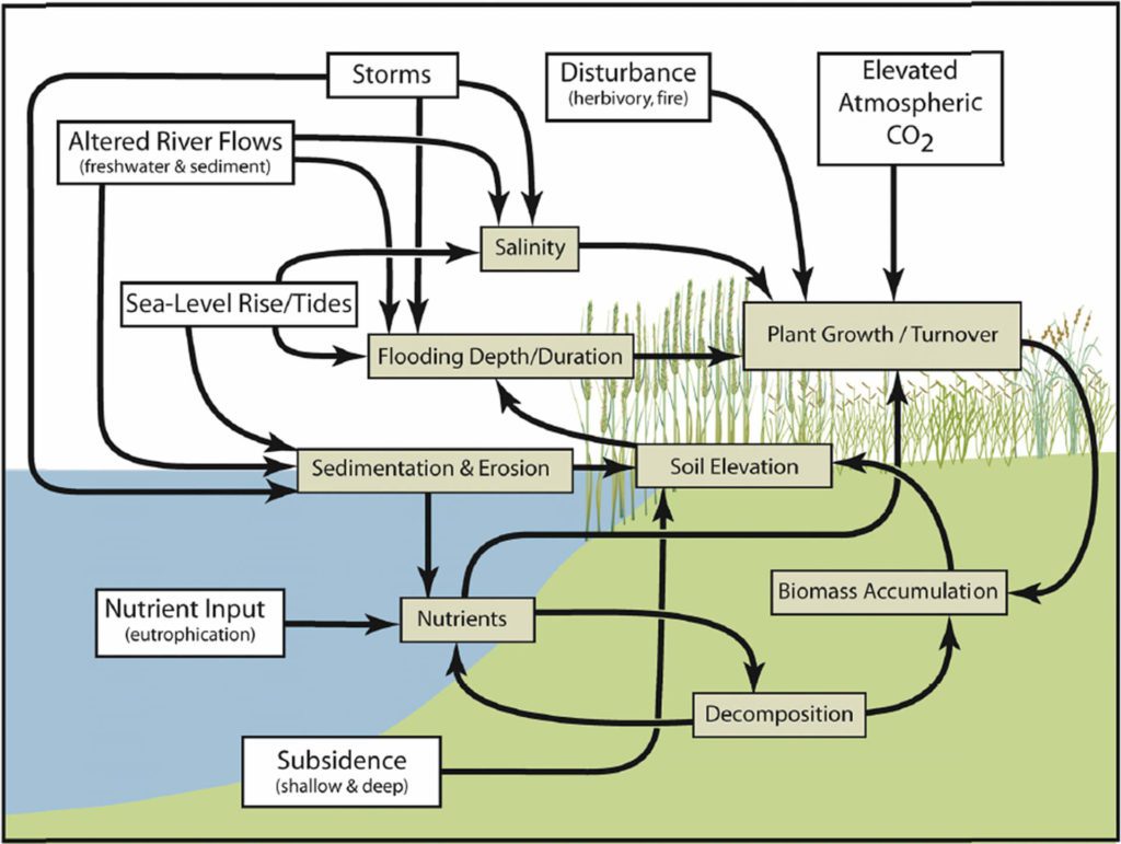
Below is a conceptual model of a tidal salt marsh with substantial tidal inputs of mineral sediment. Source: The National Academies of Sciences, Engineering, and Medicine. 2017. Available online here.
Soil erosion
Soil erosion is a natural process. Erosion can be chronic and/or episodic. Chronic erosion is constant and occurs during significant rainfall. Episodic erosion occurs occasionally, and sediment often moves in a big pulse, such as during a storm event or series of storm events. Landslides are an example of episodic erosion.
The Petaluma River watershed is composed of a highly erodible rock type, especially in the eastside hills, which has the potential to generate large volumes of sediment. When detached soil and rock particles (sediment) from erosion enters a water system, it settles out (sedimentation) depending on water flow and location — at a tunnel carrying a stream or open drain under a road or railroad (culvert), in a stream channel, in a pond or reservoir, or in an estuary. While some sediment is needed to bring nutrients and building materials to aquatic ecosystems, too much sediment causes problems and impacts flooding and water quality. Sedimentation can reduce the capacity of watercourses to hold stormwater flows, thereby increasing flooding.
Fine soil particles fill in wetlands and cement stream bottoms into uniform surfaces that no longer provide nooks and crannies to shelter young fish and the aquatic animals they eat causing a decline of salmon and steelhead trout. Sediments can also contain toxic chemicals and plastic bits that look like food, another major cause of the decline of many animal species in streams, marshes, and the ocean.
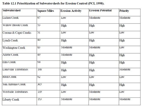
Sources of erosion in our watershed were listed in the draft Petaluma River Enhancement plan:
These sources of sediments significantly increase the total amount delivered to the water channel network affecting both navigation and water-carrying capacity. Total accumulation also depends on sea-level changes so expanding oceans from increased temperature and ice melting will bring in more sediment, raising the entire marsh over the next 50 years by at least one foot. However, water rise of over two feet drowning most vegetation, so much of our marsh is expected to turn into mudflat without higher plant vegetation.
Dredging
Dredging is the removal of built-up sediments in the river channel to protect against flooding of our downtown area while permitting more robust river traffic. Digging deeper and wider channels and straightening the curves to improve riverboat traffic changes the natural system. Nature will fill in any sediment we remove from the bottom of the channel to bring it back to its historical natural balance. For more information on dredging read the Dredging webpage.
References and Source of Materials:
The National Academies of Sciences, Engineering, and Medicine. 2017. Effective Monitoring to Evaluate Ecological Restoration in the Gulf of Mexico. Washington, DC: The National Academies Press. DOI: 10.17226/23476. Available online here.
Petaluma River Enhancement Plan. Available online here.
Sonoma County Resource District. Draft Petaluma River Enhancement Plan. Available online here.
Texas A&M University-Corpus Christi. Freshwater Inflow chapter section 8.3.1 Salinity. Available online here.
University of Chicago Marine Biological Laboratory. Available online here.